

The National Weather Service has compiled preliminary data about Thursday’s deadly tornado and storms that hit Logan and Auglaize counties.
There were three fatalities in Logan County, as previously reported in the Examiner, and 27 injury victims as a result of the storm, according to the report.
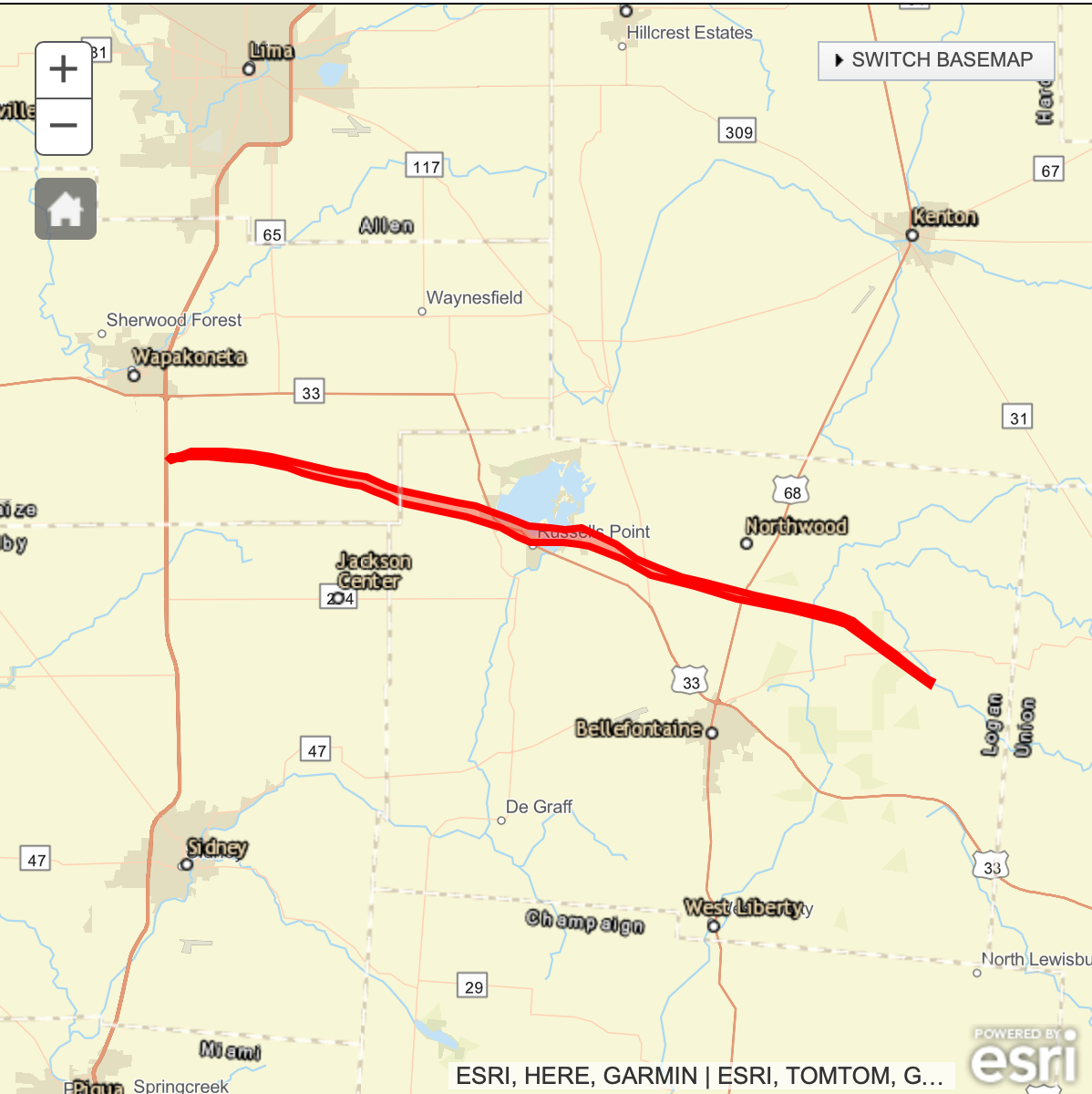
The EF3 tornado had a duration of about 47 minutes. It started around 7:29 p.m. March 14 near Botkins east of I-75 in Auglaize County and ended at 8:16 p.m in eastern Logan County, according to the report.
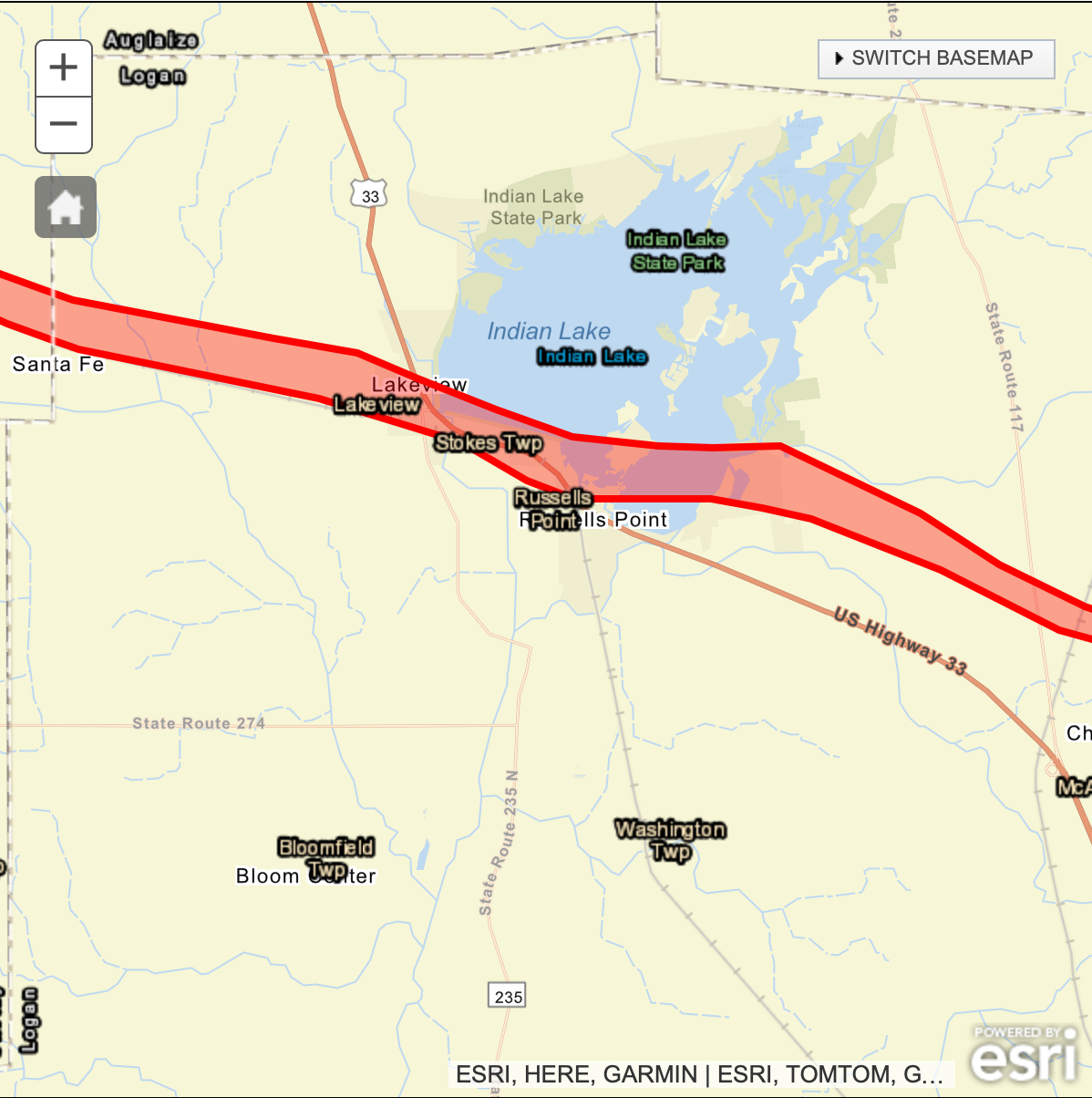
The twister was reportedly upwards of a mile wide when it ripped through a section of Lakeview. It had an estimated top wind speed of 155 mph, and a total path length of 31.2 miles.
Read the full NWS statistics and summary about the tornado below. Graphics provided by NWS.
Public Information Statement
National Weather Service Wilmington OH
330 PM EDT Mon Mar 18 2024
…NWS DAMAGE SURVEY FOR 03/14/2024 TORNADO EVENT…
…EF3 tornado confirmed in Auglaize County and Logan County OH…
Start Location……………..3 N Botkins in Auglaize County OH
End Location……………….3 WSW West Mansfield in Logan County OH
Date………………………03/14/2024
Estimated Start Time………..7:29 PM EDT
Estimated End Time………….8:16 PM EDT
Maximum EF-Scale Rating……..EF3
Estimated Maximum Wind Speed…155 mph
Maximum Path Width………….1000 yards
Path Length………………..31.2 miles
Beginning Lat/Lon…………..40.5193 / -84.1664
Ending Lat/Lon……………..40.3908 / -83.5944
* Fatalities…3
* Injuries…..27
SUMMARY
The tornado began immediately east of Interstate 75 south of Wapakoneta, immediately causing damage to a farm on the west side of Cemetery Road.
Video shared on social media showed the tornado rapidly strengthened west of Glacier Hill Lakes RV Resort causing significant damage to a grove of trees west of the resort.
After crossing a field, the tornado moved through the center of the resort, lofting campers and snapping trees. The tornado continued eastward toward Wapak-Freyburg Road, causing significant damage to the Resort clubhouse and residential homes on the west side of the road. The collective damage done to the trees and buildings within this corridor of damage justified wind estimates of 140 mph, EF-3. The tornado moved into an open field east of Wapak-Freyburg Road at an unknown intensity.
Three-tenths of a mile south of Pusheta Road, the tornado caused significant tree damage to three separate groves of trees as it neared Town Line Road. Ariel images provided by the Auglaize County EMA/CERT confirmed the tornado was still strong, at least EF-2 strength, south of Pusheta Road. The tornado likely remained fairly strong as it impacted homes and outbuildings along Town Line Road, Ashburn Road, and Geyer Road. A brief weakening period, or narrowing of the tornado was observed near Geyer, where the tornado remained mainly over open fields.
The next period of intensification occurred between State Route 65 and Valley Road. Damage to a few homes and outbuildings, along with significant damage to a few groves of trees confirm this period of intensification. The tornado began to make a more significant southeast turn between Wrestle Creek Road and Valley Road. The strong, likely EF-2 tornado continued to move southeastward into Logan County, causing additional periods of significant tree damage north of Sante Fe. The tornado continued southeast across Township Highway 85, Township Highway 84 and County Road 83. Numerous hardwood trees were uprooted or snapped and one outbuilding was also destroyed.

The tornado strengthened as it approached the village of Lakeview, producing severe damage over much of the Lakeview area and beginning along Pine Street and Poplar Court. On Poplar Court, one single family residence was destroyed, with all walls collapsed. A corridor of severe damage continued directly southeast across Main Street, where wall collapse was noted along one business building and another well built construction was destroyed. Another single family home on North Oak Street, just to the east of US 33 and west of Indian Lake, also had all walls collapsed from the tornado. The most significant damage occurred along this stretch of Lakeview, with maximum winds up to 155 mph, which corresponds to EF-3 on the Enhanced Fujita Scale. The width of the tornado was likely near mile at this point.
Damage, primarily of EF-2 magnitude, continued southeast of Lakeview, affecting areas near US 33 and State Route 366. The survey team noted roofs removed from single family homes, several outbuildings being destroyed and also destruction of numerous manufactured homes. One business near the intersection of US 33 and Township Highway 239 had total wall collapse, indicative of 140 mph winds, or low end EF-3 damage.
The tornado then crossed a portion of Indian Lake and moved across Orchard Island. Numerous manufactured homes were completely destroyed in a mobile home park area at Orchard Island, with the damage on Orchard Island rated as high end EF-2. The tornado moved over another section of Indian Lake, producing damage over a community on the eastern side of the lake, affecting Park Drive, Maple Street and Walnut Street. Several homes had their roofs completely removed, although most walls remained standing.
The tornado continued to move to the southeast, crossing State Route 366 and Route 177 to the north of Huntsville. The tornado had weakened to EF- 1 intensity at this point, with hardwood tree damage and outbuilding damage or destruction noted. Damage became much more sporadic and weaker across eastern Logan County with some minor tree damage noted just southwest of West Mansfield.
It remains uncertain whether this tornado ends in eastern Logan County or connects to a tornado confirmed in western Union County.The National Weather Service is continuing to investigate damage and these results are preliminary.
The National Weather Service would like to thank the Auglaize County Emergency Management Agency, the Logan County Emergency Management Agency, the Ohio Emergency Management Agency and several other state and local jurisdictions for providing assistance and support with this survey.
EF Scale: The Enhanced Fujita Scale classifies tornadoes into the
following categories:
EF0…Weak……65 to 85 mph
EF1…Weak……86 to 110 mph
EF2…Strong….111 to 135 mph
EF3…Strong….136 to 165 mph
EF4…Violent…166 to 200 mph
EF5…Violent…>200 mph
* The information in this statement is preliminary and subject tochange pending final review of the event and publication in NWS
Storm Data.$$
Lott/McGinnis/Peloquin/Shobe2/Isaac